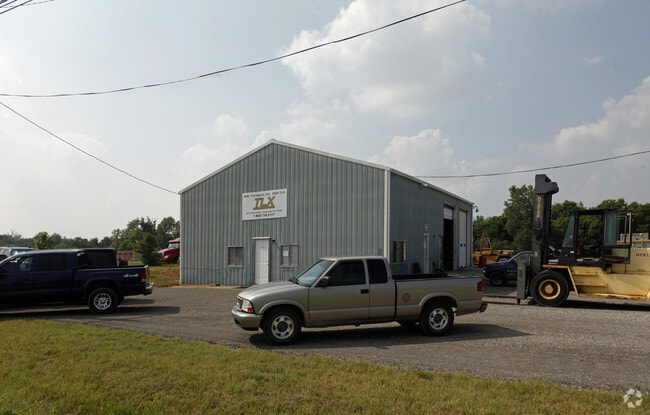
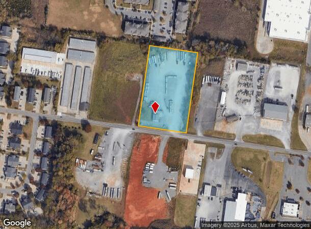
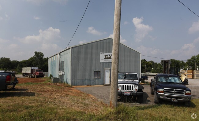
Property Record
191 Terminal Rd, Clarksville, TN 37040
NEARBY LISTINGS FOR SALE OR LEASE
Property Detail
191 Terminal Rd
032-022.01
TRUCKING AC CORR T-09
Agriculturalland
Montgomery
X
Tennessee
47125C0235D
3.44 AC
2025
Montgomery County
2024
Nashville
102005
Clarksville, TN-KY
2,160 SF
DEMOGRAPHICS near 191 Terminal Rd
1 Mile
3 Mile
5 Mile
2024 Total Population
6,345
41,851
95,942
2029 Population
7,411
49,102
112,927
Pop Growth 2024-2029
+ 16.80%
+ 17.33%
+ 17.70%
Average Age
32
33
33
2024 Total Households
2,706
15,415
34,423
HH Growth 2024-2029
+ 17.33%
+ 17.89%
+ 18.30%
Median Household Inc
$61,275
$66,911
$69,970
Avg Household Size
2.40
2.70
2.70
2024 Avg HH Vehicles
2.00
2.00
2.00
Median Home Value
$177,383
$223,626
$241,205
Median Year Built
2002
2003
2002
Nearby Places
- Restaurants
- Banks
- Shops
- Fitness
- Groceries
SALE & LEASE HISTORY
LISTING DATE
SALE/LEASE

Mar 07, 2023
For Lease
Nearby Properties
Address
Land Use
TOTAL SIZE
Lot Size
Zoning
Address
Land Use
TOTAL SIZE
Lot Size
Zoning
347,706 SF
1,332.17 AC
M-2
Address
Land Use
TOTAL SIZE
Lot Size
Zoning
1,079,305 SF
158.54 AC
M-2
Address
Land Use
TOTAL SIZE
Lot Size
Zoning
508,880 SF
54.83 AC
C-2
Address
Land Use
TOTAL SIZE
Lot Size
Zoning
231,242 SF
89.91 AC
R-1
Address
Land Use
TOTAL SIZE
Lot Size
Zoning
582,699 SF
87.68 AC
M-2
Address
Land Use
TOTAL SIZE
Lot Size
Zoning
975,102 SF
89.66 AC
M-2
Address
Land Use
TOTAL SIZE
Lot Size
Zoning
825,436 SF
134.26 AC
M-2
Address
Land Use
TOTAL SIZE
Lot Size
Zoning
695,064 SF
84.65 AC
C-3
Address
Land Use
TOTAL SIZE
Lot Size
Zoning
115,869 SF
19.93 AC
R-1A
Address
Land Use
TOTAL SIZE
Lot Size
Zoning
66,511 SF
22.90 AC
M-2
Address
Land Use
TOTAL SIZE
Lot Size
Zoning
571,253 SF
52.55 AC
M-2
Address
Land Use
TOTAL SIZE
Lot Size
Zoning
106,906 SF
26.14 AC
AG
Address
Land Use
TOTAL SIZE
Lot Size
Zoning
75,232 SF
17.75 AC
C-5
Address
Land Use
TOTAL SIZE
Lot Size
Zoning
1,136,820 SF
94.07 AC
C-5
Address
Land Use
TOTAL SIZE
Lot Size
Zoning
28,896 SF
18.22 AC
R-4
Address
Land Use
TOTAL SIZE
Lot Size
Zoning
3,591 SF
68.65 AC
C-5
Address
Land Use
TOTAL SIZE
Lot Size
Zoning
30,722 SF
9.01 AC
O-1
Address
Land Use
TOTAL SIZE
Lot Size
Zoning
20,701 SF
21.05 AC
R-4
Address
Land Use
TOTAL SIZE
Lot Size
Zoning
22,032 SF
19.62 AC
R-4
Address
Land Use
TOTAL SIZE
Lot Size
Zoning
56,774 SF
8.90 AC
C-2
Address
Land Use
TOTAL SIZE
Lot Size
Zoning
30,318 SF
11.32 AC
R-4
Address
Land Use
TOTAL SIZE
Lot Size
Zoning
28,794 SF
10.38 AC
R-4
Address
Land Use
TOTAL SIZE
Lot Size
Zoning
91,300 SF
1.05 AC
C-2
Address
Land Use
TOTAL SIZE
Lot Size
Zoning
202,136 SF
22.01 AC
C-4
Address
Land Use
TOTAL SIZE
Lot Size
Zoning
184,877 SF
24.22 AC
M-2
Address
Land Use
TOTAL SIZE
Lot Size
Zoning
65,524 SF
12.28 AC
R-1
Address
Land Use
TOTAL SIZE
Lot Size
Zoning
11,056 SF
3.91 AC
R-1
Address
Land Use
TOTAL SIZE
Lot Size
Zoning
26,218 SF
17.29 AC
C-5
Address
Land Use
TOTAL SIZE
Lot Size
Zoning
95,116 SF
5.37 AC
C-5
Address
Land Use
TOTAL SIZE
Lot Size
Zoning
17,402 SF
9.25 AC
R-1
The World's #1 Commercial Real Estate Marketplace
Connect with us
© 2025 CoStar Group
The information above has been obtained from sources believed reliable. While we do not doubt its accuracy we have not verified it and make no guarantee, warranty or representation about it. It is your responsibility to independently confirm its accuracy and completeness. Any projections, opinions, assumptions, or estimates used are for example only and do not represent the current or future performance of the property. The value of this transaction to you depends on tax and other factors which should be evaluated by your tax, financial, and legal advisors. You and your advisors should conduct a careful, independent investigation of the property to determine to your satisfaction the suitability of the property for your needs.